
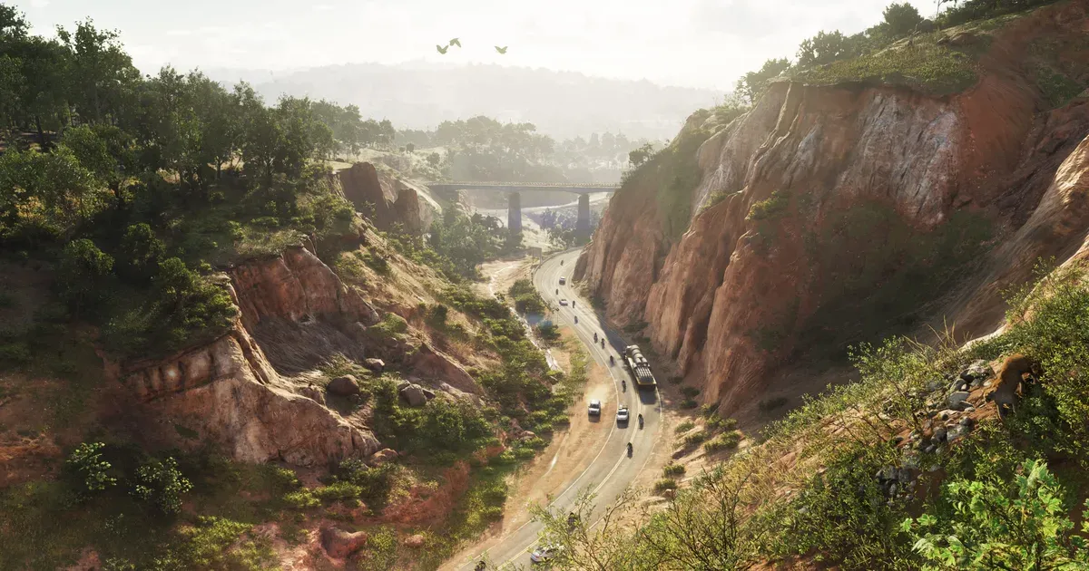
Mt. Kalaga is Leonida’s forested highland region. If Rockstar’s history with Mount Chiliad is any guide, it’s where GTA 6’s deepest secrets will be buried. Here’s everything confirmed about the area so far, and the theories worth watching.
Key Takeaways
- Mt. Kalaga isn’t one real place. Rockstar is stitching together Georgia’s Providence Canyon, North Carolina’s Table Rock, and Florida’s Suwannee River and Okefenokee Swamp into a single cohesive biome.
- A 2022 debug-code leak confirmed animal AI systems, including flocking, taming, and horse avoidance, technology carried over from Red Dead Redemption 2.
- Official screenshots show a cougar stalking a deer herd, including a buck bedding down in a pose that appears to be new for a Rockstar game.
- Rockstar has described the region’s human residents as “hillbilly mystics and paranoid radicals,” a real and well-documented subculture of the North Florida and Georgia mountain border.
Where Is Mt. Kalaga on the Map?
Status: Confirmed. Official material places Mt. Kalaga National Park in the northern reaches of Leonida, well away from the coastal sprawl, and Rockstar’s own marketing copy places the park at the map’s northern edge. For a full overview of all confirmed regions, check out our complete guide to the GTA 6 Leonida map. Observation towers, ranger stations, and winding trail networks all appear in released footage. Fire lookout towers are a real fixture of Appalachian and North Florida forest management, built to spot wildfire smoke before it spreads, and giving Mt. Kalaga its own network of them tracks with how seriously the region’s fire-danger signage and orange-glow screenshots are being treated elsewhere in the map’s marketing material.
Unlike the industrial docks we’ve broken down in Port Gellhorn, Mt. Kalaga is pure wilderness, the largest uninterrupted natural space Rockstar has shown so far, and a canyon highway running through the region may double as a travel corridor connecting it south toward the farmland of Ambrosia.
How Big Is Mt. Kalaga?
Status: Analysis. It’s tempting to look at current community fan-maps and assume the wildlife region is small, but that read is misleading. The most detailed GTA 6 mapping projects built so far don’t even include Table Rock, the mountain visible in Rockstar’s own official screenshots, or any of the terrain north of it. That means the community’s best current map is missing a chunk of territory Rockstar has already confirmed exists. For a sense of how much room a single body of water can take up on this map, the real Lake Okeechobee that anchors Ambrosia covers roughly 730 square miles on its own, and nobody has seen official material showing Lake Leonida’s actual size or shoreline yet. Mt. Kalaga is very likely being under-mapped right now, not because it’s small, but because Rockstar simply hasn’t shown enough of it.
Its Real-World Basis
Status: Confirmed inspiration. Mt. Kalaga isn’t a copy of one location, it’s a composite. The canyon formations visible in official screenshots are modeled on Providence Canyon State Park in southwest Georgia, and the canyon’s origin story is stranger than fiction: the land was flat Georgia farmland until the mid-1800s, when settlers plowed the hillsides incorrectly and rainfall eroded the exposed soil into gullies. Within roughly 30 years those gullies had grown into canyon walls up to 150 feet deep, earning the site recognition as one of Georgia’s Seven Natural Wonders, entirely because of a 19th-century farming mistake (Providence Canyon State Park, Wikipedia, retrieved 2026-08-06).
The peak itself most closely resembles Table Rock in North Carolina’s Linville Gorge, a flat-topped Blue Ridge landmark. The “Table Rock” name shows up more than once in the southern Appalachians, and the best-documented version of the legend behind it belongs to the Table Rock that straddles the North Carolina-South Carolina line further south: the Cherokee called it Sah-ka-na-ga, “the great blue hills of God,” and held that a giant once used its flat summit as a dining table (Table Rock Watershed historical marker, retrieved 2026-08-06). Kalaga’s own name is reportedly drawn from a Cherokee word for “east” or “sunrise.” Real Table Rock in Linville Gorge tops out around 3,900 feet, a fraction of the tallest peak in the eastern United States:
Table Rock, Mt. Kalaga’s real-world peak inspiration, against Mount Mitchell, the highest point east of the Mississippi. Sources: Table Rock, Wikipedia and Mount Mitchell, Wikipedia (retrieved 2026-08-06).
The river running through the region tells its own story. The waterway visible in an official kayaking screenshot, complete with a railroad bridge overhead and a flood gauge on the bank, looks modeled on the real Suwannee River, which drains out of the Okefenokee Swamp in southeast Georgia and runs largely unaltered for about 246 miles through limestone banks and hardwood forest to the Gulf. The Okefenokee itself holds the largest undisturbed peat deposit in North America (Suwannee River, Wikipedia, retrieved 2026-08-06). The railroad bridge in that screenshot has been matched to the real Hillman Bridge near Ellaville, Florida, and that flood gauge might not just be decoration, it could be Rockstar hinting that water levels change dynamically in-game.
None of these places share a single real map, but they all share the same cultural and ecological DNA: northern Florida and southern Appalachia. If you want a preview of the feel before GTA 6 launches, load up Red Dead Redemption 2 and spend time around Roanoke Ridge. Rugged forested hills, isolated cabins, dangerous strangers in the backwoods, and prime hunting territory, swap the 1899 setting for a modern one, push it south toward Florida, add a canyon and a river system, and you’re close to what’s waiting in Mt. Kalaga.
Wildlife and Outdoor Activities
Status: Confirmed (partial). Trailer footage and official screenshots confirm deer, cougars, foxes, squirrels, and raccoons in the region, but it’s how Rockstar introduced them that matters more than the species list. One screenshot shows a cougar stalking a deer herd at a watering hole, while a buck in the background lies bedded down in a full-awareness pose, watching the predator. That bedding-down behavior appears to be new, no earlier Rockstar game, including Red Dead Redemption 2, has shown a deer doing this.
There’s a technical reason to take that seriously: a 2022 debug-code leak confirmed Rockstar was building animal intelligence, taming, flocking, and a system specifically called horse avoidance directly into GTA 6. The flocking system is almost certainly what’s driving the herd behavior in that screenshot, and it lines up with the animal AI benchmark Rockstar already set in Red Dead Redemption 2, birds diving for fish, wolves coordinating hunts, bears you could deescalate by standing still. Combined with visible hiking trails and dirt roads, the region’s confirmed and implied wildlife points to:
- Hunting and wildlife encounters in the deep forest, likely extending to hog hunting, black bear, wild turkey, and venomous species like rattlesnakes and cottonmouths, all native to this exact terrain
- Off-road racing on trail networks built for dirt bikes and quads
- Hiking and exploration with observation towers as vantage points
- Possible horses. Florida has close to 400,000 horses statewide according to a 2018 American Horse Council survey cited by UF/IFAS (UF/IFAS Ocala Equine Science Center, retrieved 2026-08-06), and northern Florida specifically has a well-documented equestrian culture. Rockstar cut a heist mission involving horse theft from GTA V at the last minute, reportedly to avoid tipping its hand on the horse tech it was building for Red Dead Redemption 2. With that tech long since finished, leaving horses out of this specific region would be an odd choice for a studio that prides itself on realism
Read together, this isn’t just a handful of confirmed animals, it’s evidence that Rockstar is building a genuine wildlife ecosystem rather than a collection of independent, wandering critters. The terrain also implies several bird species that could be carried over wholesale from Red Dead Redemption 2’s asset library, and Grass Rivers just south of Mt. Kalaga looks built to extend that same ecosystem logic into wetland terrain the mapping community hasn’t been able to document in detail yet, there simply isn’t enough official screenshot or trailer material covering it.
The Backwoods and the Big Secret Theory
Status: Theory. Rockstar has described the people living in Mt. Kalaga’s backwoods as “hillbilly mystics and paranoid radicals” far from the reach of government. That’s not just flavor text, it’s a real and well-documented subculture along the North Florida and Georgia mountain border: armed, self-sufficient communities organized around the belief that when the system collapses, they’ll be the ones prepared for it.
There are stranger threads too. One screenshot appears to show an abandoned cement manufacturing plant, a building type with essentially no basis in Mt. Kalaga’s Georgia-inspired terrain, exactly the kind of anomaly that tends to reward players who go looking for what a location isn’t supposed to have. Official artwork has also shown a fire-danger sign for the region, and a news-helicopter screenshot captures an orange glow over Mt. Kalaga that could simply be sunset, or could tie into the same burning-fields imagery Rockstar has used for Ambrosia further south. Wildfire season is a real and recurring threat across this part of the Southeast, so either reading is plausible on its own.
Mount Chiliad’s mural kept the GTA V community digging for the better part of a decade. Mt. Kalaga has the same core ingredients: remote terrain, structures overlooking nothing obvious, and a level of deliberate prominence in official material that feels intentional rather than incidental. Between the flood gauge, the cement plant, and whatever else is still hiding in these screenshots, this is the region worth watching frame by frame once trailers start dropping in earnest.
Frequently Asked Questions
Is Mt. Kalaga based on a real place in GTA 6?
It’s a composite of several real places: Georgia’s Providence Canyon State Park for the canyon terrain, North Carolina’s Table Rock for the peak, and Florida’s Suwannee River and Okefenokee Swamp for the river system.
Will there be horses in GTA 6’s Mt. Kalaga?
Not officially confirmed, but a 2022 debug-code leak referenced a “horse avoidance” animal AI system, and northern Florida’s real equestrian culture makes the region a strong candidate if horses do appear.
What wildlife has been confirmed for Mt. Kalaga?
Official screenshots confirm deer, cougars, foxes, squirrels, and raccoons, shown interacting with flocking and predator-prey AI behavior. Hog hunting, black bear, wild turkey, and venomous snakes are likely but unconfirmed additions based on the region’s real terrain.
Does Mt. Kalaga have a Mount Chiliad-style secret?
Nothing is confirmed, but the region shares Mount Chiliad’s ingredients: remote terrain, unexplained structures like an out-of-place cement plant, and a level of prominence in official material that has the community watching closely.
Is Mt. Kalaga bigger than it looks on current GTA 6 fan maps?
Likely yes. Current community mapping projects don’t yet include Table Rock or the terrain north of it, both of which appear in Rockstar’s own official screenshots, meaning the region’s true footprint is still underrepresented.
The rural stretches around Ambrosia share this backcountry character, but Mt. Kalaga’s elevation makes it unique on a map otherwise defined by water and wetland.